
William Henry Holmes
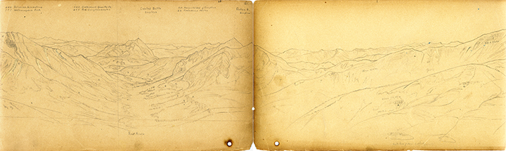
East River in center, with Crested Butte in middle ground. Sheet number 65/61.
View to the right of East River and Crested Butte. Sheet 65A
EXPLORATION: U.S. Geological and Geographical Survey of the Territories (Hayden Survey).
Colorado, 1873.
Photographic reproduction of original sketches.
Courtesy of USGS Library.
This sketch was used for the 1873 survey, Embracing Colorado. It was included as a fold out map reproduced several times smaller than the original. Notice the horizon line and due south which is marked on the drawings. Also, showing the knowledge these explorers had at the time the different layers of rocks in the East River Valley are labeled. It is possible that this drawing was made at the same time as William Henry Jackson’s photograph of the same view.